🗓️Land Surveyor Events & Conferences - Land Surveyors United - Global Surveying Community
Geospatial World Forum 2024
Geospatial World Forum 2024 May 13, 2024 at 12:00am to May 16, 2024 at 1:00amLocation: Rotterdam, NetherlandsCreated by: ⚡Survenator⌁Geospatial World...
Enclosure: https://landsurveyorsunited.com/events/geospatial-world-forum-2024
more info...
Land Surveyors’ Association of Washington
Land Surveyors’ Association of Washington Feb 28, 2024 at 12:00am to Mar 1, 2024 at 1:00amLocation: Tulalip Resort & CasinoCreated by: ⚡Survenator⌁ LSAW Conference 2024 February 28 -...
Enclosure: https://landsurveyorsunited.com/events/land-surveyors-association-of-washington
more info...
American Association for Geodetic Surveying (AAGS) Annual Conference 2024
American Association for Geodetic Surveying (AAGS) Annual Conference 2024 Mar 6, 2024 at 11:00am to Mar 7, 2024 at...
Enclosure: https://landsurveyorsunited.com/events/american-association-for-geodetic-surveying-aags-annual-conferenc
more info...

Surveyor Apps and Community Updates - Land Surveyors United - Global Surveying Community
Find Land Surveying Jobs Anywhere with Surveying Jobs App
Find Land Surveying Jobs Anywhere with Surveying Jobs App Find Land Surveying Jobs Anywhere in the world inside this...
Enclosure: https://landsurveyorsunited.com/notes/find-land-surveying-jobs-anywhere-with-surveying-jobs-app
more info...
We're On a Roll! 2 Site Redesigns and a New Smarketplace Aggregator
We're On a Roll!  2 Site Redesigns and a New Smarketplace Aggregator Our community has always had many moving parts, which extend beyond the community itself.   We help surveyors find jobs in surveying, source equipment for the field and we help our trusted vendors find customers who need their products and services.   Anything...
Enclosure: https://landsurveyorsunited.com/notes/we-re-on-a-roll-2-site-redesigns-and-a-new-smarketplace-aggregato
more info...
👷 July Updates Land Surveyors United Members - New Navigation, Jobs, Spreadsheets and More...
👷 July Updates Land Surveyors United Members - New Navigation, Jobs, Spreadsheets and More... Update for Members:   New Navigation and quick access to tools and forums Big welcome to all of our new members on Land Surveyors United!   Just 100 more surveyors and we'll be at 20,000 worldwide!  Wow!   We should be running...
Enclosure: https://landsurveyorsunited.com/notes/july-updates-land-surveyors-united-members-new-navigation-jobs-sp
more info...
Land Surveying Company Directory for USA
Land Surveying Company Directory for USA Add Your USA Surveying Company to the Directory One of the recent trends which seems to envelope USA Based surveying companies is becoming...
Enclosure: https://landsurveyorsunited.com/notes/land-surveying-company-directory-for-usa
more info...
New Member "Quick View" Feature Added to Community
New Member For over a decade, one of the most requested features from members of the community is a way to hover over a member for a quick snapshot of their profile (like Facebook and Twitter) before having to...
Enclosure: https://landsurveyorsunited.com/notes/new-member-quick-view-feature-added-to-community
more info...
Use The New Resume Generator for Land Surveyors to Find a Job
Use The New Resume Generator for Land Surveyors to Find a Job Check out the new Resume / CV Generator Tool for Land Surveyors to find a job in Surveying.     Editing Your...
Enclosure: https://landsurveyorsunited.com/notes/use-the-new-resume-generator-for-land-surveyors-to-find-a-job
more info...


Land Surveyor Forum - Land Surveyors United - Global Surveying Community
Looking for 1Hz RINEX data in Pittsburgh
Hi,I'm a Hungarian surveyor and our company is working with Mobile Laser Scanning System in the US. Our next target is Pittsburgh, but we found CORS stations only far from the...
Enclosure: https://landsurveyorsunited.com/forum/topics/looking-for-1hz-rinex-data-in-pittsburgh
more info...
Surveying Works For Roads Construction
Surveying Works For Roads Construction Land Surveying Works for Roads Construction Using SurveyingX Mobile App  ...
Enclosure: https://landsurveyorsunited.com/forum/topics/surveying-works-for-roads-construction
more info...
Surveying in USA vs Europe
Hello all, New here. I am currently a Registered Land Surveyor in the United States. What...
Enclosure: https://landsurveyorsunited.com/forum/topics/surveying-in-usa-vs-europe-1
more info...
Attachment tripod screw size in Sokkisha TS20
Attachment tripod screw size in Sokkisha TS20 Hi, I've just bought an old Sokkisha TS20 theodolite, and I realize...
Enclosure: https://landsurveyorsunited.com/forum/topics/attachment-tripod-screw-size-in-sokkisha-ts20
more info...
Surveying Newbie
I'm looking for information on how to get into the surveying field.......where does one begin?
Enclosure: https://landsurveyorsunited.com/forum/topics/surveying-newbie
more info...
Topcon PS-103A Power Station 3 Robotic Total Station
Topcon PS-103A Power Station 3 Robotic Total Station Up for sale is a Topcon PS-103A Power Station 3 Robotic Total Station kit in excellent...
Enclosure: https://landsurveyorsunited.com/forum/topics/topcon-ps-103a-power-station-3-robotic-total-station
more info...

Land Surveyor Blogs - Land Surveyors United - Global Surveying Community
✊✊✊ 18,000+== Land Surveyors Strong 💥💥💥
✊✊✊ 18,000+== Land Surveyors Strong 💥💥💥 Wow... Another 300+ Surveyors have joined the community since the last milestone, putting us at...
Enclosure: https://landsurveyorsunited.com/profiles/blog/list/16-900-land-surveyors-strong
more info...
Digest: 🧠 Massive Updates to Community - New Toolkits and Features -👀
Digest: 🧠 Massive Updates to Community - New Toolkits and Features -👀 Welcome to all of our new members of the Community!   I have taken the past 2 weeks to dramatically trim down and scale back over 11,000 pages inside the community, making the pages load MUCH faster...
Enclosure: https://landsurveyorsunited.com/profiles/blog/list/digest-massive-updates-to-community-new-toolkits-and-features
more info...
Land Surveying is For the Future World
Land Surveying is For the Future World Land surveying is a whole world in itself, which involves measuring and mapping the world around us using mathematics, advanced software, and equipment. Land surveyors are capable of calculating just about anything on the ground, in the sky, or at the bottom of the sea and it also includes...
Enclosure: https://landsurveyorsunited.com/profiles/blog/list/land-surveying-is-for-the-future-world
more info...
Case Study On Implementing Public Road Cadastre System in Sri Lanka
http://weare2013.blogspot.com/2020/05/case-study-on-implementing-public-road.htmlAbstract Accurate cadastral maps define legal repositories of land ownership, value and location by registering and representing...
Enclosure: https://landsurveyorsunited.com/profiles/blog/list/case-study-on-implementing-public-road-cadastre-system-in-sri-lan
more info...
How to Draw Centerline Chainage of an alignment in AutoCAD instantly
How to Draw Centerline Chainage of an alignment in AutoCAD instantly In this excel file I have used some excel formula to draw the centerline chainage of an alignment in Road , Railway or...
Enclosure: https://landsurveyorsunited.com/profiles/blog/list/how-to-draw-centerline-chainage-of-an-alignment-in-autocad-instan
more info...
In Search of Ambassadors of Land Surveying - SURVambassadors
In Search of Ambassadors of Land Surveying - SURVambassadors With now well over 16.800+ members from all corners of the world, our community is growing at a fast rate and need your help with moderation of your local group on Land Surveyors United.  You can see all of our location-based group forums listed here .  If you do not see a group...
Enclosure: https://landsurveyorsunited.com/profiles/blog/list/in-search-of-ambassadors-of-land-surveying-survambassadors
more info...

Land Surveying Video Guides - Land Surveyors United - Global Surveying Community
How to calculate land area? #AREA-CALCULATION
How to calculate land area? #AREA-CALCULATION welcome to the Engineer boy.Please follow on.... YouTube: @engineerboyofficialTikTok: @engineerboyofficialInsta : @engineerboyofficialFacebook: @engineerboyo...
Enclosure: https://landsurveyorsunited.com/video/how-to-calculate-land-area-area-calculation-2
more info...
Control Point Tutorial: CONTROL POINT AND TOOL LOCATION BEST PRACTICES
Control Point Tutorial: CONTROL POINT AND TOOL LOCATION BEST PRACTICES Here are 9 best practices that will help you station your total station on accurate control points on your jobsite. Best Practices for Control Points and Tool Setup in the Field When it comes to...
Enclosure: https://landsurveyorsunited.com/video/control-point-tutorial-control-point-and-tool-location-best-pract
more info...
how to convert csv file to shp area file
how to convert csv file to shp area file To convert a CSV file to a shapefile, you can follow these steps: Open a GIS software like QGIS or ArcGIS. Import the CSV file into the...
Enclosure: https://landsurveyorsunited.com/video/how-to-convert-csv-file-to-shp-area-file
more info...
How to set up a Surveying Total Station #Shorts
How to set up a Surveying Total Station #Shorts Rami Tamimi is an American doctorate student at The Ohio State University working towards his Doctor of Philosophy in Geodetic Engineering. With...
Enclosure: https://landsurveyorsunited.com/video/how-to-set-up-a-surveying-total-station-shorts
more info...
How to Offset and Elevation Layout with Robotic Total Station
How to Offset and Elevation Layout with Robotic Total Station In this video I take you with me on a simple total station setup and an easy layout of one offset from gridline and we set a few benchmarks. Structural steel survey and layout are critical processes necessary for building a solid foundation for any construction project. The use of a robotic...
Enclosure: https://landsurveyorsunited.com/video/how-to-offset-and-elevation-layout-with-robotic-total-station
more info...
Understanding Datum and Sea Level in Surveying for Construction and Engineering
Understanding Datum and Sea Level in Surveying for Construction and Engineering This video will help you to understand datum and sea level in surveying during surveying work on site. Site engineering involves using various instruments an...
Enclosure: https://landsurveyorsunited.com/video/understanding-datum-and-sea-level-in-surveying-for-construction-a
more info...

Surveying Articles - Land Surveyors United - Global Surveying Community
The Crucial Role of Land Surveyors in Land Development Projects
The Crucial Role of Land Surveyors in Land Development Projects What is the role of a land surveyor in land development projects? Land development...
Enclosure: https://landsurveyorsunited.com/articles/the-crucial-role-of-land-surveyors-in-land-development-projects
more info...
What is "Double Rodding" in Land Surveying?
What is Double rodding is a technique used in land surveying to ensure the accuracy of measurements taken with a leveling instrument, such as a level or transit. The...
Enclosure: https://landsurveyorsunited.com/articles/what-is-double-rodding-in-land-surveying
more info...
Helpful Checklists for Land Surveyors (Boundary, Staking, Level Loop, GPS RTK)
Helpful Checklists for Land Surveyors (Boundary, Staking, Level Loop, GPS RTK)   Land surveying is an intricate and critical profession that plays a pivotal role in property delineation, infrastructure development, and geographical mapping. In this...
Enclosure: https://landsurveyorsunited.com/articles/helpful-checklists-for-land-surveyors-boundary-staking-level-loop
more info...
CURIOUS STATIC DATASETS
CURIOUS STATIC DATASETS I have been using VRS for project location for some years. I need to set up a control network for the Highway Department using a static network. I dug out the old Ashstech Extremes to set up the network. When...
Enclosure: https://landsurveyorsunited.com/articles/curious-static-datasets
more info...
Are Land Surveyors Licensed Professionals? Understanding the Importance of Licensing in Land Surveying
Are Land Surveyors Licensed Professionals? Understanding the Importance of Licensing in Land Surveying Land surveying is a complex field that requires specialized knowledge and skills to accurately measure and map land. When undertaking any land surveying project, it's crucial to work...
Enclosure: https://landsurveyorsunited.com/articles/are-land-surveyors-licensed-professionals-understanding-surveyors
more info...
The Best Land Surveyor Resources You Might Not Be Using
The Best Land Surveyor Resources You Might Not Be Using Land Surveyors United Community will turn 15 years old in 2022!  We've come a long way, together.  Keeping this community alive has been a labor of love to say the least.   My love for all...
Enclosure: https://landsurveyorsunited.com/articles/the-best-land-surveyor-resources-you-might-not-be-using
more info...

Land Surveyors Dictionary - Land Surveyors United - Global Surveying Community
What is Spatial Data?
What is Spatial Data? Spatial data, also known as geospatial data, is a term used to describe any data related to or containing information about a specific...
Enclosure: https://landsurveyorsunited.com/almanac/what-is-spatial-data
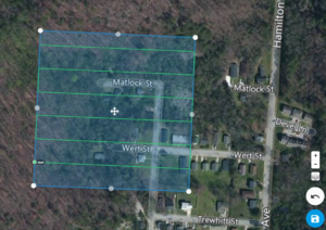
more info...
Land Surveying ACRONYMS
Land Surveying ACRONYMS     Land surveying is an essential part of construction and engineering projects. It involves determining the boundaries and features of a piece of land using various tools and techniques. To communicate effectively, land surveyors use various abbreviations and acronyms to...
Enclosure: https://landsurveyorsunited.com/almanac/land-surveying-acronyms
more info...
Surveyor Compass
Surveyor Compass Compass surveying is a type of surveying in which the directions of surveying lines are determined with a magnetic compass, and the length of the surveying...
more info...
Improvement Location Report (ILR)
Improvement Location Report (ILR) One of the questions that I receive on a lot of occasions is "What...
Enclosure: https://landsurveyorsunited.com/almanac/improvement-location-report-ilr
more info...
Ranging
When a land surveyor locates and establishes points between two survey stations, that act is called ranging. There are two conventional methods of ranging: the direct...
Enclosure: https://landsurveyorsunited.com/almanac/ranging
more info...
Construction Staking
Construction Staking What is Construction Staking?Surveying measurements that are made prior to, or while a site is under construction, to control the horizontal position and vertical position (elevation).For example, Surveyors typically place stakes at building corners for a new house...
Enclosure: https://landsurveyorsunited.com/almanac/construction-staking
more info...

Latest Activity on Land Surveyors United - Global Surveying Community
The surveyor hub for Alabama Land Surveyors was featured
Author: landsurveyorsunited@gmail.com
more info...
The surveyor hub for California Land Surveyors was featured
Author: landsurveyorsunited@gmail.com
more info...
The surveyor hub for Arkansas Land Surveyors was featured
Author: landsurveyorsunited@gmail.com
more info...
The surveyor hub for Arkansas Land Surveyors was featured
Author: landsurveyorsunited@gmail.com
more info...
The surveyor hub for Alabama Land Surveyors was featured
Author: landsurveyorsunited@gmail.com
more info...
The surveyor hub for Alaska Land Surveyors was featured
Author: landsurveyorsunited@gmail.com
more info...

📸 Land Surveying Photos - Land Surveyors United - Global Surveying Community
keep going
keep going
Enclosure: https://landsurveyorsunited.com/photo/fbe45b93-2e16-407b-a46b-f8595794d1e4
more info...
steel
steel
Enclosure: https://landsurveyorsunited.com/photo/fb-img-14819810658822820
more info...
No bipod No problem 😅🤣🫣😂 — at Quezon Province Philippines.
No bipod No problem 😅🤣🫣😂 — at Quezon Province Philippines. No bipod No problem 😅🤣🫣😂 — at Quezon Province Philippines.
Enclosure: https://landsurveyorsunited.com/photo/no-bipod-no-problem-at-quezon-province-philippines
more info...
port
port
Enclosure: https://landsurveyorsunited.com/photo/311668682-6257730987588493-5488077190803053689-n
more info...
gps
gps
Enclosure: https://landsurveyorsunited.com/photo/the-sea-man-4
more info...